Garmin BlueChart® g3 Vision® HD - VUS012R - Tampa - New Orleans - microSD™/SD™
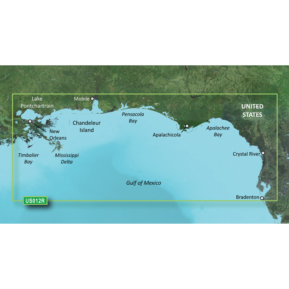
BlueChart® g3 Vision® HD - VUS012R - Tampa - New Orleans - microSD™/SD™
Coverage:
Bradenton, FL through New Orleans, LA including Apalachicola, Mobile, the Mississippi Delta, Chandeleur Islands, and a portion of Timbalier Bay. Also covers Lake Ponchartrain
Premier Coastal Navigation Charts
- Provides industry-leading coverage, clarity and detail with updated coastal charts that feature integrated Garmin and Navionics® data
- Auto Guidance¹ technology uses your desired depth and overhead clearance to calculate routes and show a suggested path to follow
- High-resolution relief shading combines color and shadow to give you an easy-to-interpret, clearer view of bottom structure than contour lines alone
- Depth Range Shading provides up to 10 depth ranges, enabling you to view your target depth at a glance
- Up to 1’ contours provide a more accurate depiction of the bottom structure for improved fishing charts and navigation in swamps, canals and marinas
Experience unparalleled coverage and brilliant detail on the water. BlueChart g3 Vision coastal charts provide industry-leading coverage, clarity and detail with integrated Garmin and Navionics data, Auto Guidance technology and high-resolution relief shading..
Auto Guidance Technology
The Auto Guidance feature¹ uses your desired depth and overhead clearance to calculate a route and a suggested path to follow.
High-resolution Relief Shading Feature
High-resolution relief shading combines color and shadow to give you an easy-to-interpret, clearer view of bottom structure than contour lines alone.
Up to 1’ Contours
The closer the contour lines, the more accurate the depiction of the bottom structure for improved fishing charts and navigation in swamps, canals and marinas.
NOAA Raster Cartography
If you prefer your display to have the look of paper charts, NOAA raster cartography2 is available as a free downloadable feature via the ActiveCaptain® app.
Depth Range Shading
This feature provides up to 10 depth ranges, enabling you to view your target depth at a glance.
Shallow Water Shading
This feature allows you to use shading to designate the shallow water depths you need to avoid.
High-resolution Satellite Imagery
These detailed images of ports, marinas, bridges and navigational landmarks help provide you with superior situational awareness.
Unique 3-D Views
MarinerEye and FishEye views provide additional perspective both above and below the water line.
¹Auto Guidance is for planning purposes only and does not replace safe navigation operations
²Raster cartography cannot be viewed on echoMAP CHIRP and ECHOMAP Plus combos but can be viewed on mobile devices via the ActiveCaptain mobile app
 WARNING: This product can expose you to chemicals which are known to the State of California to cause cancer, birth defects or other reproductive harm. For more information go to P65Warnings.ca.gov.
Get Instant Access To Our Dealer Website
Featuring wholesale pricing on products from over 300 manufacturers, your CWR dealer account will also give you access to product automation software. Automatically add, update, and maintain products on your website. The best part? It’s free!
Top Selling Garmin Products
Over 300 Brands at Your Fingertips
We have great relationships with some of the most respected and reliable brands in the business and we are here to pass on the benefits of those relationships to you, the client. With CWR, you can be assured that our customer service team is providing the best, most accurate, and most up-to-date information about your products.
Become a CWR dealer and get:
- instant access to our dealers-only website
- Wholesale pricing from over 300 brands
- No minimum order
- Flat rate shipping as low as $9.95
- Free FTP and website integration
BECOME A DEALER